Mon State stands along the upper part of the Tanintharyi coastal strip. There are islands, hills, equatorial forests, crop land and plantations. Mawlamyine, the third largest city in Myanmar, is the capital of Mon State. The famous Kyaikhtiyo Pagoda is located north of Kyaikhto. Thaton is the capital of ancient Mon Kingdom, much earlier than Bagan. There are many beautiful sea resorts such as Kyaikkami and Setse. There is a War Memorial in Thanbyuzayat, connected with the Bridge on the River Kwai.

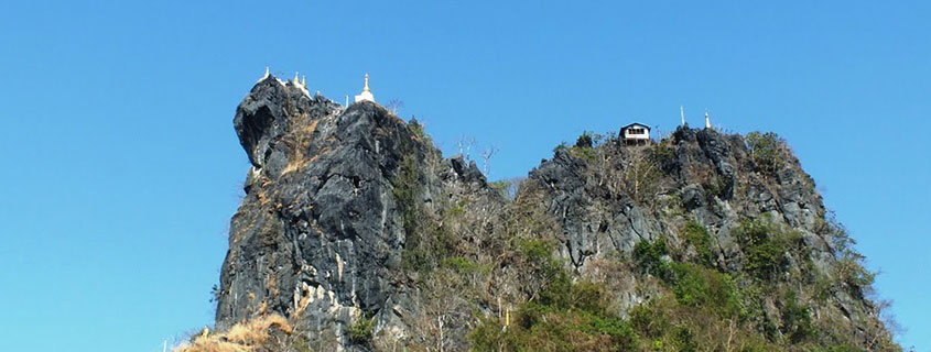
Kyaikhtiyo (Golden Rock)
The famous legendary Pagoda on the Golden Rock about 160 Km from Yangon and 11 km of hiking from the base camp at Kyaikhto. This pagoda is situated on a rocky mountain 3615 ft above sea level. The Kyaikhtiyo pagoda is one of the most ancient and celebrated of all pagodas in Myanmar. It is situated in the vicinity of Kyaikhto township, Thaton district. The pagoda is said to have been built during the life-time of the Buddha over 2400 years ago.
Before, it was a rare place which was very hard to reach. Nowadays, there are many more convenient transportations and Kyaikhtiyo Pagoda can be accessible easily. There are also convenient accommodations for visitors.
Thaton
In the early centuries of the Christian era the Mons were settled in the region between the Sittaung and Salween (Thanlwin) rivers which was known as the Mon kingdom of Ramanyadesa. Thaton, the seat of this kingdom was also known as Suvannabhumi or the Golden Land, which also applies to the whole region of continental south-east Asia around the Bay of Bengal. Doubtless Thaton was flourishing port in ancient and there was constant intercourse between Southern India and the region around Thaton and Pegu (Bago). The old city of Thaton appears to have built on a quadrangular plan like the more modern cities of Amarapura and Mandalay. There are two ramparts in a rectangular shape and the moat lies between the two walls, which are faced with laterite stones. As the present town is developed within the old city the remains of the inner city are no more visible. The chief pagodas are situated between the palace site and the south wall.
Mawlamyaing
Mawlamyine (or Moulmein) is the capital of the Mon State. It is also the third largest city in the country, after Yangon and Mandalay. It has a population of about 240,000. Mawlamyine is an ancient Mon town. The name according to the legend comes from Mot-Mua-Lum, meaning "one eye destroyed". In this legend an ancient king had three eyes, the third eye in the centre of the fore-head having the power of seeing what was going on in surrounding kingdoms. The King of a neighbouring country gave his daughter in marriage to the three-eyed king, and this queen was eventually able to destroy the all-seeing third eye. The atmosphere of post colonial decay is still palpable here. It’s also an attractive and tropical town with a ride of stupa-capped hills on one side and the sea on the other side. Mawlamyine was the capital of British Burmese from 1827 to 1852, during which time it was a major teak port.
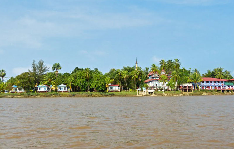
Gaungsay Kyun
Gaungse Kyun meaning Head Wash Island in Myanmar. This beautiful little islet off Mawlamyine’s north- western end is a good picnic spot. The islet was named Head Wash Island because the yearly royal hair washing ceremony during the Inwa (Ava) period, used the water taken from a spring on the island. It was believed to be named during the 19th century. You can take a stroll around and visit the Sandawshin pagoda, a whitewash and silver pagoda enshrining hair relics of the Buddha, and a Buddhist meditation centre by the pagoda. It is famous for the hair washing ceremonies.
Mudon
Mudon 29 km south of Mawlamyine is well known for cotton weaving. The mountains to the east are a source of jungle food-deer, snake and other wild forest species for restaurants in Mudon itself. Just north of Mudon is Ayin Dam, a water storage and flood control facility that's also used to irrigate local rubber plantations. Kangdawgyi Lake is a tip-top picnic spot for locals. At the northern end of the lake stands, Kangdawgyi Pagoda named after the lake.
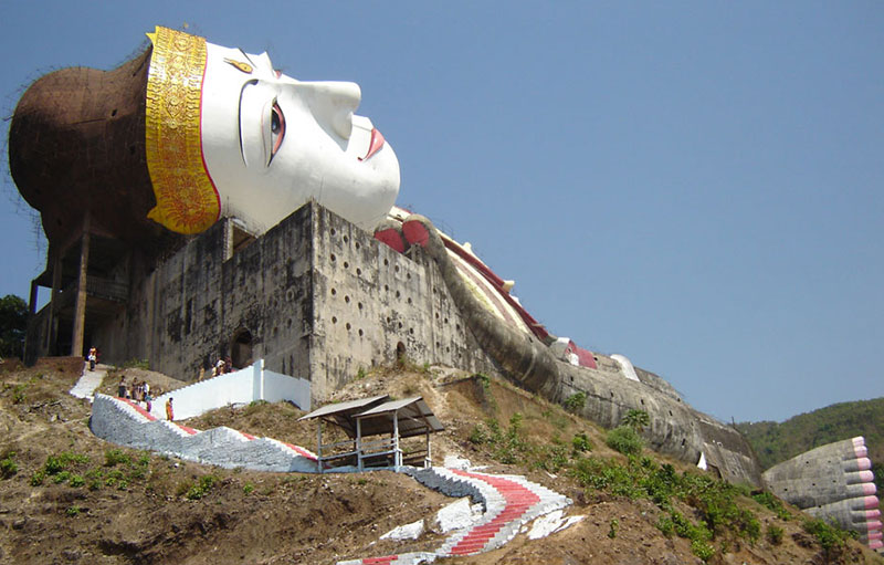
The world's largest reclining Buddha Image is under construction at Win Sein Taw Ya Forest, situated 29 km south of Mawlamyine. The Buddha Image is named as Zinathuka Yan Aung Chantha, which has a length of 400 feet (= 180 m) and a height of 110 feet (nearly 34 m). Inside the image are 182 rooms on 8 stories. Near to the Buddha Image are 200 standing monks collecting alms.
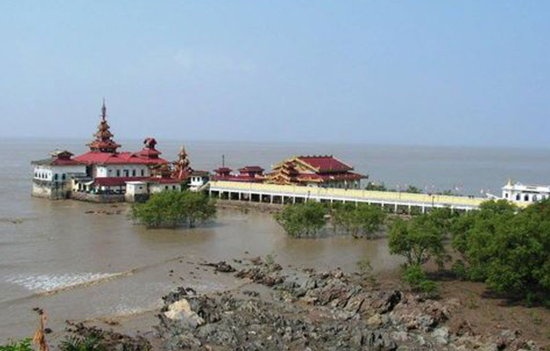
Kyaik Ka Mi Pagoda
Located 9 kms northeast of Thanbyuzayat, Kyaikkami was a small coastal resort and missionary center known as Amherst during the British era. The main focus of Kyaikkami is Yele Paya, a metal-roofed Buddhist shrine complex perched over the sea and reached via a long two-level causeway; the tower level is submerged during high tide. Along with 11 Buddha hair relics, the shrine chamber beneath Yele Paya reportedly contains a Buddha image that supposedly floated here on a raft from Sri Lanka in ancient times. Other attractions here are the colonial administrative buildings that are nearly 100 years old.

Thanbyuzayat
Thanbyuzayat - or “tin shelter” is 30 km south of Mawlamyine. It was the western terminus of the infamous Burma-Siam Railway, dubbed the ”death railway” by the thousands of Allied prisoners of war (and Asians who were forced by the Japanese military to build it. A kilometer west of the clock tower in the direction of Kyaikkami lies the Thanbyuzayat War Cemetery, which contains 3,771 graves of Allied prisoners of war who died building the railway.
Most of those buried were British, but there are also markers for American, Dutch, and Australian soldiers. Other places that record the historic events at this town are Japanese-built temples and a small museum with a locomotive, which marks the beginning of the "death railway." Two miles outside the town is the ancient city of Waguru (13th century). The walls are still plainly visible and the view from the hilltop is wonderful.